
Our Home Planet is Not Round at the End!
Credit: NASA, ESA
- October 8, 2026
- CAVU Aerospace UK
When we look at Earth from space, it appears almost perfectly spherical. However, our planet is far more complex than a simple ball. Earth rotates, its mass is unevenly distributed, and its interior contains materials with different densities. These factors create a subtle but scientifically important variation in Earth’s gravitational field. To understand the true shape of our planet, scientists use a model known as the geoid — a representation of Earth’s shape based on its gravity and the average level of the oceans. The geoid reveals that Earth’s shape is not determined by its surface alone. It is also influenced by the invisible forces operating deep inside the planet.
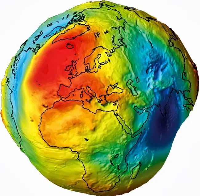
The geoid is an imaginary surface that represents the level the oceans would assume under the influence of Earth’s gravity and rotation if the water could extend beneath the continents through an interconnected system of channels. In practical terms, it approximates mean sea level extended around the entire planet. Unlike a perfect sphere or a simple mathematical ellipsoid, the geoid has an irregular shape. In some regions, it lies slightly above the reference ellipsoid; in others, it lies below it. These variations reflect differences in Earth’s gravitational field.
The geoid is not the physical surface of Earth. Mountains, valleys, ocean trenches and continental plateaus rise above or extend below it. Instead, it provides a reference surface for measuring elevations and understanding Earth’s gravity.
Three major factors explain why Earth’s shape differs from a perfect sphere.
- Rotation: Earth bulges at the equator
Earth rotates once approximately every 24 hours. This rotation produces a centrifugal effect in the rotating reference frame, which is greatest at the equator and zero at the poles. As a result, Earth has a larger radius at the equator than at the poles. The equatorial radius is approximately 6,378 kilometres, while the polar radius is about 6,357 kilometres. This means Earth is an oblate spheroid: slightly flattened at the poles and wider around the equator.
- Uneven mass distribution
Earth’s interior is not uniform. The density and distribution of rocks, minerals, mantle material and other structures vary from place to place. Dense rock formations, mountain roots, variations in the thickness of Earth’s crust and differences in mantle density all influence gravity. These variations cause the geoid to rise or fall relative to a smooth reference ellipsoid.
- The movement of oceans and Earth’s interior
Ocean currents, tides, winds and changes in water distribution affect actual sea level. Meanwhile, the movement of tectonic plates and the slow flow of material inside the mantle continually reshape Earth’s mass distribution. The geoid is therefore a gravity-based reference model, while the real ocean surface can depart from it because of currents, temperature, salinity, winds and other effects.
Actual shape of Earth
If we could see Earth’s geoid, it would resemble a lumpy, irregular surface rather than a smooth globe. These irregularities are often exaggerated in scientific visualisations to make them visible. The real deviations from a reference ellipsoid are tiny compared with Earth’s roughly 6,370-kilometre radius. The geoid has regions where its height is relatively high and others where it is relatively low. These differences are associated with variations in gravity caused by Earth’s internal structure and mass distribution. One well-known example is the Indian Ocean Geoid Low, a broad region where the geoid lies significantly below the reference ellipsoid. Its existence is linked to complex density variations deep within Earth’s mantle. Importantly, this does not mean the ocean is simply a giant hole or that the planet is physically deformed into a dramatically uneven shape. The visual exaggeration helps scientists reveal small gravitational differences that would otherwise be almost impossible to see.
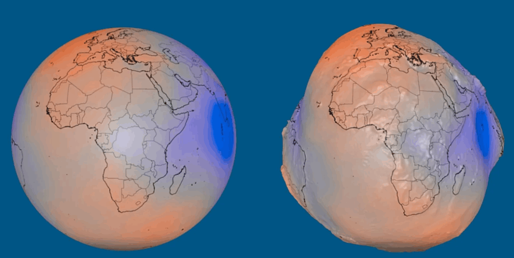
Science to Measure the Geoid
Scientists combine satellite measurements, gravity observations and mathematical models to estimate the geoid. Satellites such as GRACE and GRACE-FO measure changes in Earth’s gravity by detecting variations in the distance between two spacecraft as they travel around the planet. Other missions, including ESA’s GOCE satellite, were specifically designed to map Earth’s gravity field with high precision. Ground-based measurements and satellite altimetry also help refine these models. By combining this information, scientists can estimate how gravity varies across Earth and calculate the corresponding geoid surface.
These measurements have practical applications. Surveyors use geoid models to convert GPS-derived heights, which are initially referenced to a mathematical ellipsoid, into elevations related to mean sea level. Scientists also use them to investigate changes in ice sheets, groundwater storage, ocean circulation and Earth’s internal structure.
The geoid is not just a subject for geophysicists. It is also relevant to satellites, spacecraft navigation and our understanding of orbital mechanics. It helps to have More accurate Earth observation, better Satellite orbit determination & better Understanding Earth’s interior.
NASA QGG Mission
Earth’s geoid provides a fascinating reminder that our planet is shaped by more than its visible landscape. Rotation determines its broad, flattened form, while variations in the distribution of mass create subtle differences in its gravitational field. By measuring these differences from space, scientists can study Earth’s interior, improve satellite navigation, monitor environmental change and better understand the planets around us. The geoid connects the shape of our planet to its gravity, geology and motion through space. What looks like a simple blue sphere from orbit is, in reality, a dynamic world whose hidden structure can be explored through the precise measurement of gravity. Understanding Earth’s geoid is therefore not merely about discovering the planet’s true shape. It is about learning how Earth works — from its deepest interior to the satellites orbiting above it.
NASA’s Quantum Gravity Gradiometer project is directly related to Earth’s geoid, and it could help scientists measure Earth’s gravitational field with greater precision than existing techniques. NASA’s QGG project aims to develop a space-based instrument using ultracold atoms and quantum interference to measure tiny differences in gravitational acceleration. Unlike GRACE and GRACE-FO, which rely on measurements between two satellites, QGG could make highly precise gravity measurements from a single spacecraft. NASA is targeting an on-orbit technology demonstration no earlier than 2030.