Typhoon Edge: Bringing Real-Time Intelligence Closer to the Sensor
- April 17, 2026
- CAVU Aerospace UK
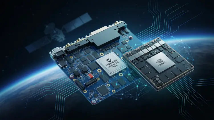
Traditional Earth Observation missions have largely depended on a collect–store–downlink–process model. Typhoon Edge is designed to move part of that intelligence directly into orbit by combining the deterministic processing capabilities of a Microchip PolarFire FPGA with the high-performance AI and GPU capabilities of the NVIDIA Jetson AGX Orin.
From Data Collection to Actionable Intelligence
In an increasingly connected world, the value of Earth Observation is no longer measured only by how much data a satellite can collect. The real value lies in how quickly that data can be transformed into actionable intelligence.
For applications such as environmental monitoring, disaster response and public safety, waiting for raw imagery to be downlinked, processed on the ground and analysed may introduce delays at precisely the moment when rapid decisions matter most.
Typhoon Edge, CAVU Aerospace UK’s high-performance edge computing OBC architecture, is designed to address this challenge. By combining the flexibility and deterministic processing of a Microchip PolarFire FPGA with the powerful GPU-based AI capabilities of an NVIDIA Jetson AGX Orin, Typhoon Edge creates a heterogeneous computing platform capable of bringing advanced processing directly into the spacecraft.
Microchip’s PolarFire architecture is particularly well suited to power- and thermally constrained embedded systems, offering deterministic processing, flexible FPGA logic and high-speed connectivity.
A New Era for Intelligent EO
Conventional Earth Observation architectures typically follow a familiar sequence:
Capture → Store → Downlink → Process → Analyse → Decide
This approach remains essential for many missions, but it can be inefficient when the spacecraft collects significantly more data than can be transmitted immediately, or when a rapid response is required.
Typhoon Edge introduces the possibility of moving intelligence closer to the point of data acquisition:
Capture → Process On-Board → Detect → Classify → Prioritise → Downlink Intelligence
Instead of treating the satellite simply as a remote sensor, the spacecraft can become an intelligent edge node operating directly in orbit.
The NVIDIA GPU can execute AI and machine-learning workloads, while the PolarFire FPGA can manage deterministic interfaces, high-speed sensor connectivity, pre-processing, data movement and mission-specific hardware acceleration. The result is a complementary architecture in which each processor can focus on the tasks for which it is best suited.
The Power of a Heterogeneous Architecture
Typhoon Edge is based on the principle that no single processing architecture is ideal for every task in a modern EO mission.
The PolarFire FPGA can provide a highly programmable and deterministic layer between multiple sensors and the AI computing subsystem. It can be used for functions such as:
- High-speed sensor interfacing
- Image and data acquisition
- Data formatting and pre-processing
- Real-time signal processing
- Sensor synchronisation
- Multi-sensor data routing
- Hardware-accelerated algorithms
- Mission-specific interface implementation
At the same time, the NVIDIA Jetson AGX Orin provides a powerful environment for GPU-accelerated computing and AI inference.
Together, these devices can create an architecture in which sensor data is acquired, prepared and delivered efficiently to AI algorithms, allowing the spacecraft to perform increasingly sophisticated analysis without waiting for ground processing.
This combination of deterministic FPGA processing and AI acceleration is particularly relevant to space systems, where power, thermal capacity and communications bandwidth are all limited resources. PolarFire devices are specifically designed around low-power operation, with Microchip highlighting their thermal efficiency and deterministic computing capabilities.
Multi-Sensor Intelligence from Orbit
Modern Earth Observation increasingly relies on more than a single optical camera.
A mission may combine visible imaging, infrared imaging, thermal sensors, hyperspectral or multispectral instruments, RF sensors, radar-derived information, telemetry & GNSS and positional data to create live tracking EO intelligence. Typhoon Edge’s architecture can support the concept of a multi-sensor intelligence platform, where information from different sources can be collected, aligned and processed as part of a unified on-board workflow.
The PolarFire FPGA can act as the flexible and deterministic interface layer connecting sensors and data sources, while the Jetson AGX Orin can perform higher-level AI processing and sensor-fusion algorithms. This creates opportunities for the spacecraft to move beyond simple image capture.
For example, an EO satellite could potentially combine visible imagery with thermal information to distinguish between different environmental conditions. Multiple observations collected over time could be analysed to identify changes, moving objects or developing events. Rather than transmitting every frame with equal priority, the system can support intelligent decisions about what information is most important to transmit first.
Enabling Live Tracking from Space
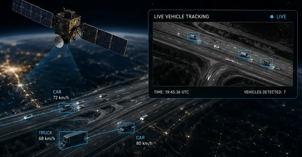
One of the most exciting possibilities enabled by reliable on-board GPU processing is near-real-time detection and tracking. A conventional imaging satellite may capture an image of an area and send that data to the ground for later analysis. With AI processing available directly on-board, a different approach becomes possible. The process chain operates as follows:
Sensor Acquisition
↓
FPGA-Based Data Handling and Pre-processing
↓
GPU-Based AI Inference
↓
Object Detection or Event Identification
↓
Tracking Across Sequential Observations
↓
Generation of Metadata, Alerts or Priority Data
Depending on the mission architecture, sensor characteristics, orbital geometry, revisit opportunities and communications availability, this approach could support near-real-time tracking and event monitoring directly from orbit.
Instead of downlinking only large volumes of raw imagery, the satellite could potentially generate valuable information such as object location, object classification, direction of movement, speed estimation, event detection, change detection, confidence levels & time and geographic metadata.
The resulting metadata package can be dramatically smaller than the original image data, potentially allowing critical information to reach operators more quickly. The original imagery can still be stored and transmitted when required for validation or more detailed analysis.
Environmental Monitoring: Turning Observations into Early Insight
Environmental changes are often gradual, widespread and difficult to monitor continuously from the ground.
An intelligent EO platform equipped with Typhoon Edge could support automated monitoring of wildfires and smoke development, flood expansion, coastal changes, deforestation, ice and glacier movement, oil spills and marine pollution, agricultural conditions, water quality indicators & land-use changes. AI algorithms operating on-board could search for specific patterns or changes between observations.
For example, instead of requiring a ground team to review every image, an AI model could identify regions that exhibit characteristics associated with a developing wildfire or flood. The spacecraft could then assign a higher priority to the relevant data. This does not eliminate the role of human analysts. Instead, it allows the satellite to act as an intelligent first layer of analysis, helping ground teams focus their attention on the information that matters most.
Faster Disaster Response
During natural disasters, time is one of the most critical resources. Floods, wildfires, earthquakes, volcanic events and severe storms can evolve rapidly. Emergency responders need timely situational awareness to understand what is happening, where the greatest impact is occurring and how conditions are changing. Typhoon Edge can support an architecture in which AI algorithms process sensor data directly on the spacecraft and identify potentially significant events.
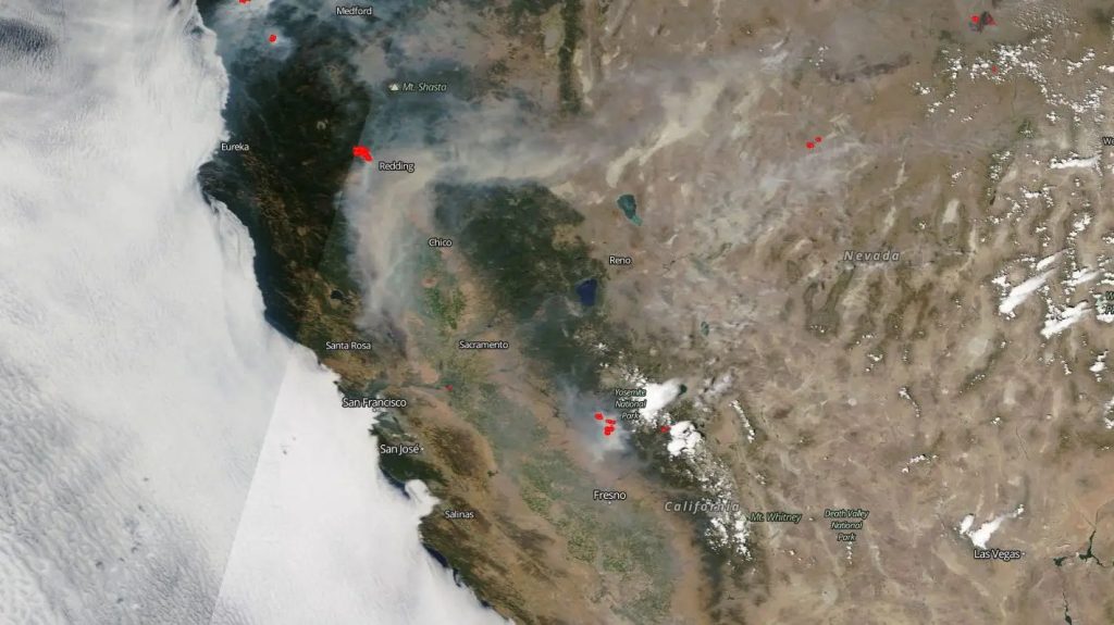
Wildfire detection is a great example. AI can analyse imagery for smoke, thermal anomalies or rapidly expanding fire boundaries. Once a possible event is detected, the satellite can prioritise the relevant imagery and generate event metadata.
Flood Monitoring- Sequential observations can be compared to identify changes in water boundaries and affected areas.
Infrastructure Assessment- AI models may assist in identifying visible changes to roads, bridges, buildings or other infrastructure following a major event.
Maritime Incidents- Multi-sensor data can potentially be used to identify unusual activity, pollution events or objects requiring further investigation. The objective is not simply to produce more data. The objective is to deliver the right information at the right time.
Supporting Public Safety and Situational Awareness
Space-based intelligence can also contribute to broader public-safety and situational-awareness applications. AI-enabled EO platforms could potentially assist operators by automatically detecting and prioritising observations related to large-scale fires, flooded regions, maritime activity, environmental hazards, critical infrastructure changes, unusual movement patterns & large-scale incidents requiring further investigation.
The combination of AI processing and multi-sensor integration makes it possible to develop mission-specific intelligence workflows. Different AI models can be deployed for different mission objectives, while the programmable FPGA architecture provides flexibility for interfacing with new sensors and implementing customized processing pipelines.
Reducing the Communications Bottleneck
One of the fundamental challenges of modern EO systems is that sensor capability is growing faster than the available downlink bandwidth. High-resolution cameras and advanced sensors can generate enormous volumes of data. However, not every pixel necessarily contains valuable information. On-board AI introduces the possibility of data triage in space.
Typhoon Edge can support a workflow in which the spacecraft:
- Acquires raw sensor data.
- Performs pre-process and sensor management using the FPGA.
- Executes AI inference using GPU resources.
- Identifies objects, events or changes of interest.
- Generates metadata and intelligence products.
- Prioritises critical data for downlink.
- Stores full-resolution source data for later retrieval when necessary.
This approach can help mission operators make more effective use of available communications capacity. The downlink can be used not only as a pipeline for raw data, but as a channel for delivering prioritised intelligence products.
Reliable Computing via pair of FPGA & GPU
Deploying advanced AI processing in orbit requires more than computational performance. A spacecraft must operate within strict power and thermal constraints while maintaining reliable operation over the mission lifetime. This is where the combination of FPGA and GPU processing becomes particularly valuable. The FPGA can manage deterministic and time-critical operations independently from higher-level AI workloads. It can continue to handle interfaces, sensor acquisition and critical data paths while the GPU executes computationally intensive algorithms.
The OBC-Hyper-Polar is also designed with an emphasis on power efficiency and reliability. Microchip’s PolarFire SoC architecture combines programmable FPGA fabric with deterministic multi-core RISC-V processing, while the wider PolarFire portfolio includes radiation-tolerant technologies developed specifically for demanding space applications. This separation of functions creates a more robust architecture for complex missions. The PolarFire FPGA handles what must happen predictably. The GPU handles what requires massive parallel computation. Together, they enable a new class of intelligent spacecraft.
The long-term vision for systems such as Typhoon Edge extends beyond simply running AI models in orbit. A future Earth Observation platform can become an autonomous edge-computing system capable of:
- Understanding what it observes
- Comparing new observations with previous data
- Detecting changes
- Identifying objects and events
- Fusing information from multiple sensors
- Prioritising mission data
- Generating actionable metadata
- Supporting faster ground decisions
This represents an important evolution in space-based intelligence. Instead of sending every observation to Earth and asking the ground segment to determine what is important, the spacecraft can assist in identifying important information immediately after acquisition. Human operators remain responsible for mission decisions, validation and strategic interpretation, while on-board intelligence reduces the time required to transform raw observations into useful information.
Typhoon Edge brings together two powerful and complementary processing technologies:
- Microchip PolarFire FPGA for deterministic processing, sensor interfacing, data handling and programmable acceleration.
- NVIDIA Jetson AGX Orin for advanced GPU computing and AI inference.
- Together, they provide the foundation for a highly capable space-based edge intelligence platform.